Peakist
For where to go
and where you've been.
Peakist is an of app to help hikers keep track of their visits to various peaks. There are many peaks to see and lists to track. Peakist helps you keep a record of where you went and when.
Peakist version 2.1 is available now with several new lists across New England, support for many map styles (topographic maps!), improved data export (take your visit data with you) more parking and camping locations now provided.
Many improvements all over the app. Search for lists, optional more compact card view, much faster map performance, list requirements view, new completion gauge, shiny new support for OS 26 Liquid Glass UI, completely redesigned in-app help to get up and running fast, and much more.
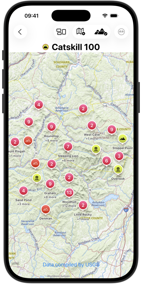
Includes lists to track peak visits all across New England with more lists being added all the time.
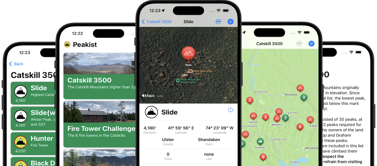
Support for over two dozen peak bagging lists (and some not peaks at all.) Something for hikers and wanderers of all abilities.
Click to see current list
Includes the following...
Peakist was created by the folks at Squirrel Point Studios in beautiful upstate New York.
When you need a fresh idea on where to venture, Peakist has a curated list of peaks to visit.
Are you a completionist who has to visit all the peaks? Peakist will help you keep a record of your visits to all the peaks.
New for version 2.0 is Grid support. Are you the ultimate completionist type? Grids may be for you. A Hiking Grid is taking a peak bagging list and completing the list in each season of the year (Seasonal Grid) or every month of the year (Annual Grid.) Peakist has grid support to help you track your obsession.
New for version 2.0 is support for basemap styling. Select from several different map styles including satellite and topographic!
While Peakist is not intended to be a navigation tool while hiking (there are many great apps already for this!) it will help you navigate to the area or a preferred parking spot. Integration with Apple Maps allows quickly getting directions from home to the peaks. Peakist also allows exporting GPS coordinates or GPX data for integration with other apps.
Data export expanded for Peakist version 2.0. In addition to exporting a location as GPX file for sharing with your favorite application or device, you can now export all your visit data. Support for exporting to plain text, comma separated values (CSV) or even JSON.
Peakist features the locations of many camping and parking areas so you can see where you can access the peaks or even plan an extended stay in the woods. Currently limited to the Catskills and Adirondacks, where New York State provides parking and camping information.
Peakist will sync your visit information between your iPhone, iPad and Mac automatically via iCloud. Plan your next hike at your desk, record your visit on the top of the mountain and review your accomplishments on your iPad.
Peakist only uses iCloud to share your visit information between your devices. None of your visit information is public. It's your information. We don't track it, sell it or share it.

Drop us a note if you have suggestions for lists/locations to be included in the app.